

Qlik Sense GeoOperations is a functionality that enables geographic analysis and is available as an Advanced Analytics Integration in Qlik Sense SaaS. The functionality enables you to solve geographic problems with your data, such as linking geographical positions to regions or road networks, determine how many potential customers are living within a certain distance or time from a business location, and finding the closest airports in an area. The GeoOperations functionality is available in scripting for both the data load script and in visualisation expressions.
How does it work?
The GeoOperations functions are available in Qlik’s script language. The functions send an operation request to the GeoOperations extension when running the script. The extension then calculates the request and returns a table with fields containing the geospatial data. The requests can operate on three different types of data sources:
- on a previously loaded table in the load script
- on an external geographical file, such as GeoJSON or ESRI Shapefiles
- by using the built-in GeoAnalytics location service
In other words, if you don’t specify the geographical data yourself, you can make use of the included Qlik GeoAnalytics Server location service. The location service provides geographical data such as countries, regional administrative divisions, cities, postal codes and airports. You can choose to return the data either as points or as areas, and you can also limit the data to one or more countries.
Once you have specified and loaded your geographical dataset, you can make use of a number of operations as listed below:
- Geometric operations, such as finding the closest objects or intersecting objects in two datasets.
- Aggregating operations, such as clustering or binning of a large number of geographical points.
- Route-based operations, such as getting routes and distances between points or within a reachable travel area based on a defined method of transport.
- Lookup operations, such as address points lookup or IP address lookups.
Script examples of GeoOperations
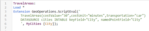
In this first example, we are using the operation TravelAreas to get the areas reachable from a list of cities. We have specified a few parameters to define our scope, in this case we are looking at the areas reachable by car within 30 minutes from a city. Furthermore, the data source used is a so-called INTABLE, or a previously loaded table in the script, where the field containing the city names is named “City” and the table name is MyCities.
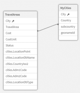
The result of the TravelAreas operation is a table that looks like this:
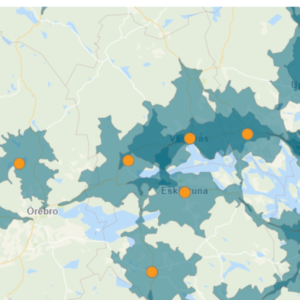
When visualising this in a map chart, the reachable travel areas from a city could look like this:
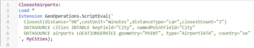
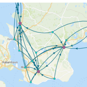
In this second example, we are using the operation Closest to find the closest airports from a list of cities. We have defined a few parameters to narrow our scope, in this case we are looking at 90 minutes driving distances by car and a maximum of the three closest airports. Again, the data source we are using as a starting point is a previously loaded table in the script named MyCities. However, we need a second dataset to make the comparison. In this example, the list of airports we are using as our ending point is retrieved from the built-in location service. We have also limited the scope to airports in Sweden returned as geometric points.
The result of this operation, may look like this in a map chart:
Summary
The GeoOperations functionality is a powerful integration for advanced analytics in Qlik Sense SaaS and offers a number of tools for analysing geographical data. Using the operations requires experience with scripting and definitely needs to be done by trial and error. Examples on how to use the operations and the available parameters can be found on Qlik’s website here.
There are some limitations to the size of the datasets that can be called in a request. The maximum number of rows for most operations are 50,000. The exceptions are route-based operations which has a maximum number of 400 rows and lookup operations which has a maximum of 20,000 rows.
Topic: Data analytics


Comments